|
Recent Adventures |
|
|
Upper, Upper Big River Stouts Creek Access Lower Rock Creek: What a Day First Descent of Flat Branch Creek The Saint, Castor, and Mud Creek The True Adventures of Chuck & Chris Leptospirosis First descent of Lower Rock Creek (new) First descent of Castor A Turkey Creek Shut-ins Christmas Eve Present (new) First Descent of Turkey Creek |
|
|
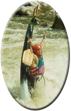
Upper, Upper Big River - by Chuck McHenry (October 30, 2009): |
|
|
Di and I woke up on Oct. 30th, 2009 and found we'd gotten 3" of rain, all within a 24 hour time period.
All the creeks north of the Taum Sauk divide were pumping. I had been scouting this run for several years
and knew it had potential. This is the run out from Council Bluff Lake. I don't think it's the original
shut-ins that were present before the lake was built, but the gradient is certainly there. I'd guess it
drops about 60 feet in a third, or a half mile.
We were disappointed that the road to the swim area was closed- and I guess they do so at the end of September, because from the beach it's just about a 50 yard paddle. As it was, we had to put in at the boat ramp- a lake paddle of about a mile. This run absolutely demands scouting. It is difficult and non-stop. The water was brown- why? I don't know coming off of the lake- but the lake itself was probably about 4 feet up. The brown was thick enough that rocks under water were impossible to see or gauge. We stopped and scouted along the length, but somehow we did not ID the horizon line that made the hardest rapid- one we named "Go Right, DI" because Di went left and got creamed. It's a slide of about 15 yards, at a 45 degree angle. Halfway down is a ledge that if you hit it sideways, will surf you. Breaking free from this ledge then puts you at the mercy of the center line which drops you into an ugly recirculating hole. Di hit this and cart wheeled into a flip. She rolled immediately. There is more rapid and boulders just downstream. Generally the action is continuous with only a few moving eddies. There are multiple standing waves of 4 feet in height, sticky holes, and boulder gardens. We did notice that when the river split, the right chute generally was easier than the left, but staying right gets you into trouble at GRD. Unless you have a bombproof roll- and I mean in fast, violent water, you probably should not attempt this run. It is a solid IV, with IV+ consequences should you be out of your boat. The end filters into trees and brush and joins the spillway water. From here the river has little gradient. The walk back up is an easy boat drag or carry along a semi-grassy, gravel road that extends up River Right and back to the lake where a grassy two-track takes you back to the lake. View pics of this run. [ back to top ] |
|
|
Stouts Creek Access - by Curtis Elwood (December 30, 2008): |
|
|
As many of you know, the put-in that many people use for middle Stouts is on private property and there have been incidents that have left
the owner upset. The problem seems to get worse every year as more and more people paddle this section. Please, please, please be sensitive
to the rights and wishes of the land owner when paddling this section.
I spoke with the owner, Tom Merello, this Sunday and he was very upset. In an effort to ease the tension, I told him that I'd post his rules on the message board. I've also added some tips to help mimize the traffic. 1) Organize at D and minimize the number of cars taken to the top. Even if you're only dropping people off, he really doesn't like that many cars on his property. I'd also suggest coordinating with other groups to stagger put-in times by 30 minutes. 2) If at all possible, use the public access point. It's the first drive after the bridge over Stouts on the right as you're heading west on 72. It will hold two cars side by side and is a gravel lot. 2WD trucks probably aren't a good idea but every other type of vehicle should get in and out just fine. 3) If you must park on his property, he asks that you call ahead. The number can be found in the link below or on the sign at the low-water bridge. http://www.missouricottages.com/find_us/index.htm 4) If he gives you permission to park on his property, he prefers that people park across the low water bridge on creek left. Eventually, he has plans to put in a small gravel lot there. If that area is full, you may park on creek right, but you must park on the left side of his driveway and only on the gravel. No not, for any reason, park on any area of the grass or block his drive. Not even just to unload. If you run out of room to unload, park across 72 on highway D and carry across. 5) If you see Mr. Merello, please be kind and ask him if you are in compliance with his wishes or if he has any changes he would like to make to them. 6) If someone tells you that they just spoke the owner and asks you to park elsewhere or act more conservatively, listen to them. One person was asked twice to not park in the middle of the road even to unload and didn't heed the request. Right in the middle of the unloading process, Mr. Merello drove up and he was delayed in getting out of his drive. It doesn't matter if you've been paddling Stouts 2 years or 20. If someone asks you to act more conservatively because they just talked to the Mr. Merello, do it. We don't need to lose this access point. Mr. Merello is truly a friend to boaters for letting us use his property to access Stouts from his property. He's put up with a lot and still lets us park there. I've paddled Stouts quite a bit and the only time there are ever issues are when everyone and their brother try to put on all at once. If we are courteous and follow the rules, we'll be able to enjoy this creek for years to come. [ back to top ] |
|
|
What a Day - by Chris Amelung (March 19, 2008): |
|
|
I can only describe today as an adventure. I can't say I would do it again under similar conditions, but I must say that Lower Rock Creek is truly an incredible place. It's ruggedly beautiful and I cannot express in words how incredible that canyon is. I've hiked it before and while it was amazing then, seeing it today with water cascading from all sides was truly an experience I won't soon forget.
Jason Bales and I boated LRC today. [ finish the story ] [ back to top ] |
|
|
First Descent of Flat Branch Creek, Columbia MO - by Steve Witzig (June 2, 2003): Paddled by: David Wilson and Steve Witzig |
|
|
Well, it's been done! David Wilson and I made the first descent of Flat Branch Creek (well as far as we can tell in talking to CARP veterans in town).
This one is the ultimate urban creek run. It starts off in Flat Branch Park with the water rushing out from underneath the Providence/Broadway interchange
in an intricate network of storm drainage tunnels that empties downtown Columbia. My guess is that the headwaters are the run-off from the streets between
College Ave (east border) Business loop (north border) and West Blvd (west border). Surprisingly, the water was clear until we were below Stadium.
It had been raining all day in Columbia. We had about 1.2" of rain, which isn't enough to bring up the other runs in town, but since Flat Branch Creek is so flashy David decided to have a look since he was already downtown. The level was perfect, so he rushed home, gave me a call (4:30pm), convinced me that it was actually up, and we devised our plan. We met at the Forum take-out 30 minutes later and ran shuttle. The water had dropped some, and we actually missed the peak level by about 30 minutes (hence the 30 minute window). A lot of the good waves and holes were too shallow to play in, but there was enough water to stay in our boats for everything but a few mandatory portages around strainers. The run starts out with a few small waves in flat branch park, and then goes through the first tunnel under Locust Street. Just past Locust Street the creek narrows even more into a micro-gorge with some small ledge drops. The second tunnel puts you under Elm Street, where you resurface just in time to make a bend and enter the long tunnel that goes under Providence Road. Just past Providence Road but before Stewart Street tunnel, there is a nice hole we're calling Delta Hole (since the DC house is on the hill above). From this point down, the creek snakes back and forth along the MKT spur of the Katy Trail. From Stewart Road down to Stadium Blvd, there were a number of small ledge drops and waves with one significant drop we're calling Quarry Falls (since its opposite of the abandoned quarry-turned swimming hole). Quarry Falls can be viewed from the MKT spur and I had scouted it many times before. It's mostly man-made consisting of boulders reinforced with concrete, not pretty, but fun! It's about a 3' drop (vertical on right, slide drop on left). There was mandatory portage at a pipeline that may be run-able left with more water, however there was a ton of debris piled on it! Approaching Stadium Blvd, there were three tunnels to choose from, the far right was the MKT spur, and middle and left were there to handle the water from the creek. Well, water was flowing through all three, but we chose the left tunnel since it looked to have the most water. It was shallow, but we made it through. Immediately after Stadium there was a few more ledges and waves, but nothing as significant as the upper section. Most of the MKT spur bridges along the lower section had trees, debris, shopping carts, etc forming nasty strainers with most of them requiring a portage. We paddled out to the confluence with Hinkson Creek, and took out on Forum. After running shuttle back up to the top (now about 7:30pm), the water running through Flat Branch Park was just a trickle! The good and the bad about this run is that it is so flashy. This means that it is rarely catch-able, but it also means that it runs before the other runs in town (and even when there's not enough water to bring the others up!). It took 3 years to catch this one at the right time with water, with the boat ready, and someone to paddle with, but I've seen it up before on various occasions. So, I've got my eye on this one and next time there is rain all day in Columbia, I'm going to wait with my boat in Flat Branch Park until the water rises enough to cover the rocks in the middle of the creek, then put on and paddle, hopefully while it is still rising! [ back to top ] |
|
| The Saint, Castor, and Mud Creek - by Jason Garrett (May 9, 2002): | |
|
Big grins and lots of fun were had by all. For the Saint we had a fairly large group. Chris Amelung, Tim O'brien, Paul A., Anie, Steve Schaeffer, Diane Duncil... a couple of guys from Springfield... I am forgetting names andmyself. We ran Roselle to D. We started
about 2:30PM. Concensus said the level was about 5 feet over as we put on. The river dropped about a foot by take out. The river was great. A few of us were just along for the ride but Chris, Paul and Tim sliced a few waves. As opposed to Wednesday... Shark's Fin was
visible again. Somehow that was comforting to me. Wednesday was way too big for me. Clean runs were had by all. We pulled out at Mud Creek and most of us ran the last 200 feet of it. I guess this area is officially called the Gauntlet but at this level, Bumper Car
would be better. It was boney and finding water to put the paddle in was hard. It was still fun. All walked the dam, of course. Yes, Don the dam is still there. We couldn't see the top so we'll have to wait till tomorrow to see if our new breach has appeared.
After running Chris, Diane, Paul, Anie and I went to Castor River. This is a great run. It is short, maybe a half mile. If you have never hiked this area even in low water it is beautiful. God did some amazing work here. The pink granite canyon walls are steep and more narrow than anywhere on the Saint. The main portion of the run is about a quarter mile. It starts with a boof or drop depending on route. Either way the bottom is shallow. Anie's inspected the rocks for us... after a quick roll she confirmed the shallowness. The boof here would disappear if the water is much lower and a vertical pin would become possible. This drop is followed by a couple smaller drops. (I like to call these Bone Crusher and Eat Your Lunch.) They are harmless. The fourth drop is more serious. We all agreed that if you flipped you could have a new face before you come up. With that all but Paul ran. I guess that should have been a clue that one of our best two boaters didn't run... but we are slow learners. Chris ran smoothly... of course. Diane flipped above the drop in a small curler. In the middle of this drop is a flat rock near the surface. From wear I sat above the drop I thought she had ordered her new face. I was happy to see her safely on shore before I ran. As I watched her bouncing upside down in the rocky river bottom I thought maybe Daine's Downfall would be a good name for the rapid. Happily... she was too unscathed to get a rapid named after her. I proceed to miss the optimal line by a couple feet. The river decided to pop me into a large rear ender before spitting me out. Aine got turned sideway in the middle of the drop and recovered with a quick roll. I am no person to offically rate rivers but I would say that if the last drop is not a class IV, the only reason is a nice recovery pool. Yesterday the level in the shut in was a good 2-3 feet higher the hole in the last drop may have held more. Well it was now after 8PM and a darkness settled over our Ansel Adams landscape... my best memory was that there was a take out along the main road after a half mile of flat water. Chris and Diane decied to hike to the putin and pick us up at this "easily found" take out right on the side of the road. Paul, Anie and I started wandering down a darkening river. "What is that... a rapid I hear?" Yes... there are two more small class II rock gardens. If it weren't getting dark there would be some good eddy lines to play. This is where the river and my memory parted ways. I hiked in the woods a bit and there was no road, ut ohhh!!! It was at this point that I seemed to remember that you had to take another road to the take out... This is one of those details that is good to share with your drivers before they leave. Well, a little further down there was a creek bed or dirt road... it was too dark to tell. I proceeded to jog down the path hoping to find the main road... there is a small parking lot but seemed to be no signs of the main road. So I turned back... then there was a light in the distance and a large black object... was is a bear looking for a lost kayaker to eat??? I quivered. It was only Chris or more properly... Chris' truck. But he didn't see me. As he slowed in the parking lot I yelled like the man standed on a deserted island. I feared he was turning in the parking lot. I felt like Tom Hanks, but sadly without a volleyball to make friends with. In a crucial moment of decision Chris thought once, then twice and even a third time and then made the definative turn. We were rescued. Rescued from the perilous darkness and impending doom. For the record at the end of highway W east of Fredricktown is a fork in the road... take it... Take it to the left and the first parking lot is the put in. Take it to the right and the only parking lot is the take out. In daylight the road would be more visible from the river. There is a small gravel bar after the second rock garden and about a half mile past the shitins, opps I mean shut-ins. The takeout is the road in front of the gravel bar. This is a fun run. Of things I've run, it most reminds me of Wolf Dells. The canyon is not that steep but it has the big starting drop and an exit drop in about the same distance. However, Castor adds a couple of 3 foot drops in the middle and the drop that exits the canyon is much bigger than the Dells exit. I believe this short section is definitely a III+ and a more authortative source may even say a low class IV. Add these runs to a Wednesday scouting the Saint and running Marble Creek and it was lots of fun. Wish you were here. [ back to top ] |
|
| The True Adventures of Chuck & Chris - by Chuck McHenry (Riverlog - June/July 1997): | |
|
It was a March Thursday and Chris Amelung was home on spring break. It'd been raining hard all day- yet the gauge on the Saint wasn't budging. At noon I checked Stout's on my lunch hour= nadage. All the water was running in the ditches- but it didn't seem to be getting
to the creek. I was off at 3:30 and checked Stout's again. It just stared back in a depraved lowlessness. So I went home to do other things, the rain was merely illusion. There was obviously a tear in the dimensional vortex. In one reality it was pouring rain, the ditches
were full and running, but all the water was flowing into a different reality's river, leaving us high and dry. Caught halfway between dry and wet realities I knew it was going to be a strange afternoon. The only thing to do was concentrate on breaking into wet universe.
I grabbed a beer to help my meditations.
Chris called at 4:00. He'd checked upper stout's = nolopolo. He was stuck in dry universe as well. I was chanting, trying to connect with wet Kundalini. 4:45 Chris called: Killarney shut-inn was barely runnable. We were starting to break on through- dry universe was slowly dissolving. We met at the Penuel take-out. [ finish the story ] [ back to top ] |
|
| Leptospirosis - obtained from Steve Witzig (written by Quinn Long): | |
|
A personal account of a Columbia paddler diagnosed with Leptospirosis
Hello local paddlers, Take leptospirosis seriously. I paddled Hinkson and Cedar creeks with steve, greg, dustin, ray and ryan after that late august storm [Aug. 2000]. Two weeks later I began getting aches and fevers. I went to Boone County [hospital] and they dismissed my 104.5 temp as the flu. I went to my parents place to deal, but it kept getting worse. Within a few days I was in the ER in Washington, MO with a 106 fever, spasms, rashes, vomiting, hellish head and body aches etc. Luckily the head ER doctor was an old family friend who took things very seriously and contacted specialist involved with the CDC. They began treating me with numerous iv antibiotics and anti viral since they had no idea what to treat. Within a day pneumonia set in and that night I went into respiratory distress (o-sat levels down to 83), my heart, which was drowning in fluid, had a pulse in the low 40's. I was transferred to St. Johns in St. Louis ICU to do a tracheal and plunk me on the respirator, but my descent stabilized in the ambulance. After several weeks in the hospital and many more elsewhere, I am completely healthy. The infectious disease specialists tell me that if Ii hadn't been so healthy to start, or if treatment were further delayed I'd likely be dead, or at least weaning myself off of the respirator and dialysis. Leptospirosis is called Weil's disease in it's more serious secondary onset such as mine. The less severe cases can go unrecognized for a year or more. The testing for this disease is real advanced and I the cause of my illness was unknown until last week. I didn't test positive until antibodies were found after my recovery. I was unsure of where I contracted it, until I read this email from Renee. If you get seriously ill after boating, remember this. DOXYCYCLINE is the preferred treatment for the illness. I hope I'm the only one who came down. Stay well, Quinn Long Centers for Disease Control (CDC) information: http://www.cdc.gov/ncidod/dbmd/diseaseinfo/leptospirosis_g.htm [ back to top ] |
|
| First descent of Lower Rock Creek - submitted by Kevin Olson (written by John Tansil - Riverlog 1990): | |
We don't have to call it "Secret" Creek anymore! On Saturday, May 26, 1990 with the St. Francis running 10 feet over highway D bridge, Slim Olsen, Chuck McHenry, Bruce Wagner, and yours truly completed the first run of Lower Rock Creek. Dubbed "Secret" Creek by the group of boaters who wanted to be the first to run it, Lower Rock Creek received its mysterious nickname after whispers of another runnable creek close to the St. Francis prompted the following conversation between the uninformed and those in the know:
	"Where is it?"
	"I can't tell you. It's a secret!"
	"Oh, a secret creek?"
	"Yeah. That's right. Secret Creek. Ha-Ha-Ha."
This conversation, repeated many times on various boating trips, not only provided a nickname for the mythical creek, but also presented convincing evidence that the social interaction between whitewater boaters is sometimes similar to that of young children. It all began in storybook fashion - the ground was saturated from previous rainfall and the Friday night TV weather radar indicated heavy rain in the Fredricktown area. Early Saturday morning a reliable source (Deep Throat?) confirmed that the St. Francis was several feet over the D bridge. Who to call? Rick Dippold and I had scouted it together, but a quick call to him revealed imminent multiple in-law visitations to witness the newborn. Nix to Rick. Greg Brown and Stan Stoy had also scouted the creek, but they were boating in Washington (remember, it's Memorial Day weekend and many club members had scheduled out-of-area trips). I didn't know whether to feel sorry for them or not. How about Chuck, Slim, and Bruce? Only way to find out is to call. I set a record and wake up all three families. A typical conversation went like this: "Slim! The Francis is way over the bridge. Today's the day to do Secret Creek." "Barb will kill me." "Yeah, I know. But this is important. We may have to wait five years for another chance." "OK. I'll meet you down there." We agree to rendezvous at Chuck's place in Ironton. I can't pass up the chance to go by the take-out on the Francis. It's an honest 10 feet over the bridge and still rising. Hot dog! I blast over to Ironton to meet the rest of the crew. We discuss logistics and agree to carry in from a point off highway D. How to get there? We sure can't go by way of Silvermines! I thought it was straightforward to enter from the other direction, but Chuck says "No, there are low-water bridges." He calls a friend in the area who confirms potential difficulty with access. Our plan is to try it anyway and if we don't return within an hour, Chuck's wife Linda is to assume that we made it to the carry-in point. She has thankfully agreed to pick us up at the take-out where Lower Rock Creek crosses highway E. With anticipation building, we set off on the shuttle. Sure enough, water is over the road in several places but we make it anyway. With the vehicles parked and secured, we walk the 2 1/2 miles to the put-in. The walking is easy with everyone dragging boats through the mud and cowpies. Sometimes it's hard to tell which is which. We put in and almost immediately have to portage a strainer. Not a good start, but then we realize we put in on a tributary and that the actual creek is less than 100 feet away. The second time things go a lot better - it's fast and narrow but easily boatable. We paddle down the river single file from the eddy to eddy with Slim leading almost the entire run. Most of the drops could be boat scouted with only a few requiring closer inspection. We named three of these. Upchuck,a two part drop, was not named for the nauseous feeling it produced, but because Chuck flipped in the first drop and as the bottom drop was particularly nasty, we were thinking "Roll up, Chuck!" Copperhead, named because one was sighted as we pulled over to scout, was a complex long rapid made more difficult by the splitting of the flow into two channels with the left one too congested. Bruce climbed a tree to scout the right channel and announced "No way, man." (say "man" to rhyme with "con") It's too gnarly." After a powwow, we decide to do it anyway one at a time with safety set up. Slim and Chuck have questionable runs but make it to the bottom. Bruce gets pinned but frees himself as I frantically scramble along shore to give assistance. It's my turn. I must have watched Bruce's line too closely since I pin in the same spot! Fortunately I'm able to get out of my boat, line up again, and do it right the second time. The last named rapid, Slimslide, consisted of two steep blind drops which had Chuck directing traffic between drops. We cruised on down the creek and reached the take-out in plenty of time to get a run in on the St. Francis at 8 feet. What a fantastic day! In retrospect Lower Rock Creek proved to be well worth the several years wait for the proper timing. In my opinion it is the best of the other steep runs in the St. Francis area, i.e. Turkey Creek, Pickle Creek, Stouts Creek, etc. This is based on its greater length, steep gradient, and the fact that there was always one clean route the whole way down. (OK, OK. So we bounced over a few rocks. That's what plastic boats are for!) In fact the length and the gradient is what got our attention in the first place. Consider the particulars:
Finally, I should point out that Lower Rock Creek is truly a beautiful unique area which has been well-known to hikers and backpackers for some time. The Sierra Club has published a brochure describing the area in the hope that the Forest Service will acquire more of its watershed and seek wilderness status. On the topographic maps Lower Rock Creek gorge is named Dark Hollow and there is certainly an aura of mystery about it. As we paddled down, it was difficult to believe this was actually in Missouri and so close to our usual run. Now the question is "How long do we have to wait to do it again?" [ back to top ] |
|
| First descent of Castor back in 1980-82 by Herm Smith: | |
|
"I led the first descent back about 1980-82 (I have slides in archives and will look up the
exact date and I could probably send you a couple of GIFS or JPEGS from them. Very funny as
I have a picture of John Ruprecht in my bow doing an airbrace at the first drop.). I know that
Jo Ann Weber-Koenig, Karl Koenig, John Ruprecht, and others were on the trip but can't remember
the others without looking in my archives in the basement. We actually discovered the shut-ins by
accident. At the time we were in Blue Hole OC-2s and aluminum canoes after a week of heavy rains
and everything was out of it's banks. We had done the Whitewater River (class II which you may want
to add) with lots of willows. We put in thinking that the Castor was just a nice float way upstream and
were pleasantly surprised to find the shut-ins when we got to them. John and I ran most of the boats
through as the aluminum paddlers weren't good enough. We named the first drop Crack in the Rock. It has
a nasty rock sieve on the right side of the middle boulder if you look carefully. We named the second drop
C-Turn for obvious reasons. The third drop we named Throat because it necks down. The final drop only
John and I ran. The water was relatively low and sprayed off the final drop so we named it Rooster Tail.
This rapid is only a III at lower levels but I saw it at a clear IV- last Spring when John Foster flipped and
swam at a terrific high level."
[ back to top ] |
|
| A Turkey Creek Shut-ins Christmas Eve Present - by Kevin Olson (Riverlog 1982 or 1983?): | |
|
(Note: this is the Riverlog story referred to by Herm Smith in the next account of Turkey's First Descent)
Christmas eve 1982 brought a special present to Janet Burnside, Herm Smith, Paul Kreuet, and Kevin Olson. We rendezvoud at the Silver Mines store because the Francis was three-fourths of the way up the hill on D (15-20 feet over the low water bridge???). Our plan was to attempt the Turkey Creek shut-ins from 72 if the water was high enough -- was it ever! The farmer on the right side of the 72 bridge let us park in his driveway although he thought we were looney. We put on about noon in rainy 68 degree warmth. The water was just barely below the 5 foot high cow gate below the 72 bridge. The first mile of water is flat and required squeezing under, over and around five cow fence-gates. The actions starts immediately after the fifth gate. Stan Stoy and I had scouted the shut-ins in October so I led the way. I warned the group that the eddies would be few and small and scouting mandatory at several spots. Just below the last gate we encountered 1/4th mile of "warm-up" class II action before the bottom dropped out -- the next half mile drops 100 feet! I eddied out on river left just above the first major drop. Paul came barreling down, missed an eddy, was committed and flipped over in a giant hole half-way down the first drop. He self-rescued himself while his boat plummeted down the stream. Janet tried to make an eddy already occupied by Kevin, and she ended up flipping over on a pillow off a boulder, but rolled immediately and continued on to an eddy where we scouted the second major drop with Paul designated as permanent safety rope thrower since his boat was nowhere to be found. This second drop was the thrill of the day. It was a 100 yard run with huge holes and waves which required precise maneuvering to avoid getting tangled in willows. It was much like a slalom course where the penalty for missing the "gate" was entrapment or death. Janet said that this run was the first time she valued her gate work at Madawaska last Summer. At the bottom of the second drop we eddied out left to scout the rapids just beyond the hair-pin left curve. The better part of valor saw us walk this one. When Stan and I scouted this one we were most concerned about it. The water careens off a gigantic boulder in mid-stream 20 feet past the hair-pin curve. The water pillows off the rock, which is badly undercut. If you take the right channel you end up smashed into willows. If you take the left one, you need to hope you aren't "pillowed" sideways into one of the two willows about four feet apart. The fourth rapid is sort of a mirror image of Bull Sluice. The water drops 90 degrees off a granite outcropping into a boiling hole on the river right and then a few more feet into a "pool." The fifth major drop requires drawing left to avoid a tree partly across the river and then a drop into large holes and waves. We found Paul's boat somewhere above this point and easily extracted it from the willows. It will require some work on the deck to fix a hole but otherwise was in good shape. After the fifth drop the river would be considered class II save for the fact that it widens and smashes among large trees. After 100 yards of "tree billiards" it suddenly stopped just above the Turkey Creek picnic area ford. The Francis was somewhat anti-climatic after Turkey -- wide, huge waves with the mandatory dam portage. We all agreed that Turkey was a beautiful gift from the river gods. Originally I thought you could do Turkey with less water but we believe we had optimal levels. The extra water raises the ACA rating into the 30's for skills needed to IV (V). It is too tight for anything but K-1's. [ back to top ] |
|
| First Descent of Turkey Creek back in 1980-82 by Herm Smith: | |
|
"I also lead the first descent of Turkey. It is written up ages ago in the
Riverlog with a description of how to avoid the cow fences by walking up
across from Mud Creek by path and woods and I don't remember exactly when
(about 1980-82) the Saint was at the second highest level I've ever seen
it--about 14 feet over the D-BRidge. We opted to try Turkey first to let
the Saint drop for a second run at 12 feet. Ron Davis said later that we
had made the correct move--He walked the shutins at the higher level while
Butch Gebhart ran it very uncomfortably as I recall although both were
excellent paddlers. I ran with Janet Burnside, Charlie Schuman, Steve
Schaeffer (the perennial expert slalom favorite of the time) and a friend
of his named Paul. Paul flipped in the first rapids and had to walk out
from a shoulder injury from which he never recovered to boat again (We put
in at the 72 bridge at a very high level!) so we called that one Shoulder
Buster. At that level, Turkey was ONE big rapid from ShoulderBuster
through
Stoy's Joy. While I was in Japan in 1985, Stan Stoy ran Turkey for the
second descent at a more reasonable level and called the last drop Stoy's
Joy: This is the one where there is a drop of about 2 feet into a big hole
followed by a 5'-7' drop over a ledge into a very dicey hole. Upstream of
Stoy's Joy where the water bounces into a wall and jets at a 90-degree
angle through willows is the other significant rapid but we didn't name
it.
I don't know what Stoy's group called it: For us, the willows were more
significant than the actual drop which is only class II at lower levels."
[ back to top ] |
|